Integrating WaPOR and GEE for IGwA
2. Executive Summary
The sustainable management of groundwater resources used in irrigated agricultural is increasingly critical in addressing global water scarcity and mitigating the impacts of climate change. This tutorial outlines the use of geospatial techniques and remote sensing data from FAO’s WaPOR and Google Earth Engine (GEE) tools, to estimate groundwater abstraction for irrigation and its recharge, assess water stress, and support decision-making for water resource management.
Key Highlights
Introduction to Remote Sensing and Analytical Tools
Remote sensing tools, such as WaPOR, and cloud-based platforms like GEE enable high-resolution spatial and temporal monitoring of water resources. These tools provide scalable and accessible methods for integrating diverse datasets into groundwater modeling and management, offering insights into hydrological processes.
Establishing GEE Pipelines and WaPOR Data Integration
The integration of WaPOR’s reference evapotranspiration and precipitation datasets with GEE’s soil property data forms a comprehensive pipeline. This enables efficient preprocessing, analysis, and visualization of hydrological data tailored to regional conditions. The pipeline facilitates seamless access and processing of data for subsequent modeling steps.
Data Preprocessing and Analysis with GEE and WaPOR
Advanced preprocessing techniques in GEE refine WaPOR datasets to create accurate and reliable inputs for groundwater modeling. The combined use of GEE and WaPOR streamlines data management, ensuring compatibility and usability for detailed water balance and recharge analyses.
Modeling Irrigation Groundwater Abstraction and Recharge
By using established methodologies like the Saxton & Rawls equations and Thornthwaite-Mather water balance calculations, soil hydraulic properties are derived. These parameters are critical for modeling infiltration, storage, and recharge processes across the vadose zone and aquifers, offering a clear understanding of groundwater dynamics in the irrigated agricultural sector.
Model Validation, Calibration, and Stress Indicators
To improve model accuracy, advanced model calibration processes are needed to align crop-specific, soil-hydraulic, and irrigation system parameters with observed data. Validation ensures the integration of high-resolution spatial datasets accurately reflects real-world water fluxes. Additionally, water stress indicators, such as the Aridity Index (AI), Groundwater Stress Index (GSI), and Seasonal Variability Index (SVI), provide actionable insights into groundwater sustainability.
Spatial and Seasonal Analysis of Groundwater Dynamics
Calibrated models generate spatial distribution maps at the field-level and conduct seasonal analyses of groundwater use, enabling field-level decision-making. These insights are visualized through interactive dashboards, offering intuitive and dynamic representations of groundwater dynamics and aiding stakeholders in developing effective water management strategies.
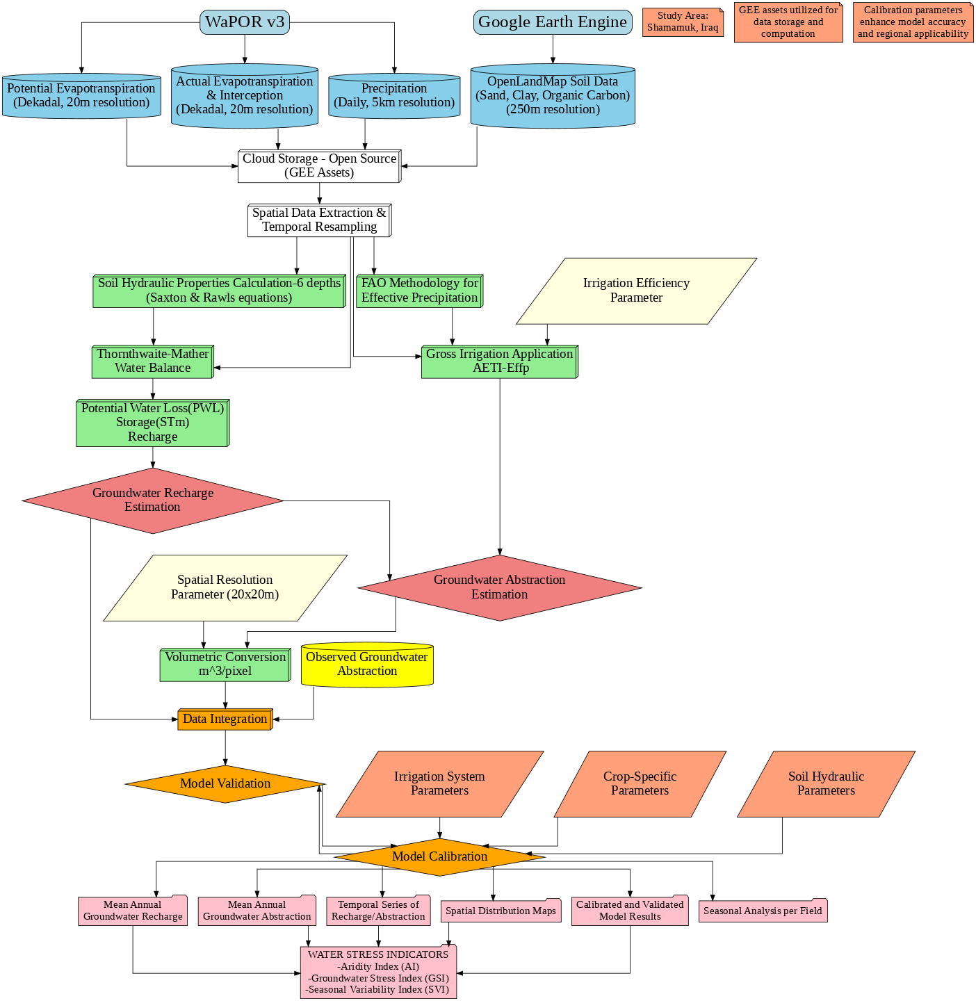
Model workflow Diagram
The methodology diagram showcases the integration of WaPOR, GEE, and observed data into a unified modeling framework. It highlights the systematic approach to groundwater abstraction for irrigation, recharge estimation, and model validation, culminating in decision-support outputs.
Conclusion
This tutorial provides a framework for leveraging remote sensing and computational tools to enhance groundwater resource management in the irrigated agricultural sector. By integrating high-resolution datasets, validated models, and actionable indicators, this approach offers scalable solutions to address the complexities of groundwater assessment in diverse regions. These methodologies could hold a significant potential for guiding sustainable practices in agricultural water use and addressing the challenges posed by water stress and climate change.